Outlook (Main)
Storm Prediction Center

-
SPC - No watches are valid as of Thu May 26 05:40:01 UTC 2022
No watches are valid as of Thu May 26 05:40:01 UTC 2022. -
SPC - No MDs are in effect as of Thu May 26 05:40:02 UTC 2022
No Mesoscale Discussions are in effect as of Thu May 26 05:40:02 UTC 2022. -
SPC May 26, 2022 0100 UTC Day 1 Convective Outlook
SPC 0100Z Day 1 OutlookDay 1 Convective Outlook NWS Storm Prediction Center Norman OK 0754 PM CDT Wed May 25 2022 Valid 260100Z - 261200Z ...THERE IS A MARGINAL RISK OF SEVERE THUNDERSTORMS FROM THE LOWER MISSISSIPPI VALLEY TO THE SOUTHERN GREAT LAKES... ...SUMMARY... Isolated strong to severe thunderstorms remain possible, primarily across the central Gulf Coast states tonight. ...01z Update... Center of upper low is currently located over northern OK. This feature will move slowly northeast tonight as stronger flow advances downstream into the lower MS/western TN Valley region. While bands of strong/severe convection have developed well ahead of this feature, primary surface front may become more convectively active later this evening across AR/LA. Both LCH and LZK exhibited weak/minimal inhibition in their 00Z soundings and isolated thunderstorms are now forming along the boundary across AR. As weak mid-level height falls spread across this region there appears to be some chance for renewed convection along the front later this evening. Earlier corridor of strong/severe thunderstorms across MS/AL has shifted a bit downstream and a few robust storms may linger across this region with some attendant threat for locally strong winds or perhaps a brief tornado. Elsewhere, scattered showers/thunderstorms persist from the TN Valley into the southern Great Lakes region. Overall trends have been down with this activity but modest shear and ample buoyancy will likely continue to support at least a few robust updrafts this evening. Primary risk appears to be locally gusty winds. ..Darrow.. 05/26/2022
Read more -
SPC May 26, 2022 0600 UTC Day 1 Convective Outlook
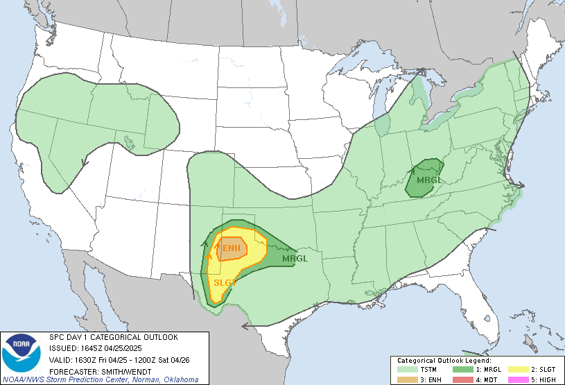
SPC 1200Z Day 1 OutlookDay 1 Convective Outlook NWS Storm Prediction Center Norman OK 1233 AM CDT Thu May 26 2022 Valid 261200Z - 271200Z ...THERE IS A SLIGHT RISK OF SEVERE THUNDERSTORMS PORTIONS OF THE PACIFIC NORTHWEST...GEORGIA INTO THE WESTERN CAROLINAS...AND THE UPPER OHIO RIVER VALLEY... ...SUMMARY... Isolated to widely scattered severe thunderstorms may occur Thursday over Ohio/eastern Kentucky, northeastern Georgia into the far western Carolinas, and parts of northeastern Oregon, southeastern Washington, and Idaho. Severe wind gusts and large hail should be the primary hazards. ...Synopsis... An upper-level low over the central CONUS is evident in early-morning water vapor imagery. This feature will continue to drift east into the southern/central Appalachians over the next 24 hours. As this occurs, a diffuse surface low and attendant cold front will shift into the OH River Valley and southeastern U.S. respectively. 00 UTC RAOBs from across these regions sampled modest mid-level lapse rates (generally between 6-7 C/km), but a broad swath of boundary-layer mean mixing ratios between 10-13 g/kg across the region coupled with diurnal warming will support adequate buoyancy for convection by early afternoon. To the west, an upper-level wave off the West Coast will move onshore later today. Height falls across the Pacific Northwest and the approach of a mid-level cold front will support thunderstorm development late in the afternoon/evening. ...Southeast... A cold front currently moving across the lower MS River Valley is expected to continue eastward into the Southeast today. Thunderstorms will likely be ongoing at the start of the period along the Gulf Coast, but will increase in coverage along the front through the late morning and early afternoon across AL into GA. Although moist profiles and modest mid-level lapse rates will limit buoyancy to a degree, MLCAPE should be adequate for increasingly robust updrafts by early afternoon. Increasing deep-layer shear off the boundary, as well as strengthening 850-700 mb flow, will support the potential for a few cells and/or organized segments along the front. A Slight risk is introduced for portions of central GA into the western Carolinas where the potential for such organized segments (and an attendant damaging wind threat) appears greatest. A diffuse wedge front, noted in early-morning observations across the Carolinas, is expected to lift north as a warm frontal zone through the day in response to increasing southerly flow. Thunderstorms may develop along this boundary during the afternoon. A few stronger, more organized cells are possible, but storm motions along the boundary and the possibility of destructive storm interference may limit this potential. ...Upper OH River Valley... Broad ascent ahead of the upper low overlaid with a mid-level convergence zone will support isolated to widely scattered thunderstorms from IL into the upper OH River Valley. Modest low to mid-level lapse rates will limit buoyancy despite 55-65 F dewpoints already in place. However, forecast soundings show adequate CAPE profiles to utilize the stronger flow aloft with 35-45 knots of effective bulk shear likely across this region. The isolated to scattered nature of convection should allow for at least a few organized cells and/or linear segments. Narrow CAPE profiles may limit the overall hail potential to a degree, but 30-40 knot flow within the lowest 1 km will support a damaging-wind potential. Recent guidance continues to suggest that the greatest convective coverage (and hence increased wind threat) will reside across northeast KY into OH and far western WV near the exit region of the upper jet. ...Pacific Northwest... 00 UTC soundings from across the Pacific Northwest have shown a general increase in mid-level moisture over the past 12 hours as deep-layer onshore flow increases. Additionally, mid-level lapse rates have steepened as broad, but weak, ascent overspreads the region ahead of the upper-level wave. This trend will continue through the day and, when coupled with daytime heating, should support around 500 J/kg MLCAPE by late afternoon. While buoyancy may be somewhat limited, straight hodographs off an initiating cold front will promote discrete cells, including the potential for a few supercells, from northeast OR into northern ID. Large hail appears probable with these cells, and steep low-level lapse rates with a 1-2 km dry sub-cloud layer will support the potential for severe wind gusts. ..Moore/Darrow.. 05/26/2022
Read more -
SPC May 26, 2022 0600 UTC Day 2 Convective Outlook
SPC 0600Z Day 2 OutlookDay 2 Convective Outlook NWS Storm Prediction Center Norman OK 1236 AM CDT Thu May 26 2022 Valid 271200Z - 281200Z ...THERE IS A SLIGHT RISK OF SEVERE THUNDERSTORMS FROM THE CAROLINAS NORTHWARD INTO PENNSYLVANIA AND NEW JERSEY... ...SUMMARY... Widely scattered severe thunderstorms are possible on Friday from the Carolinas northward into eastern Pennsylvania and New Jersey. Damaging gusts and a couple of tornadoes are the primary threats with the stronger storms in the Chesapeake Bay region. ...Synopsis... A mid-level low initially over southern IN will move east-northeastward into central PA and weaken into an open trough by early Saturday. A composite boundary will push east across the Appalachians and much of the eastern U.S. during the period. Farther west, a belt of low-amplitude, southwesterly mid-level flow will spread across the northwestern CONUS as a mid-level ridge weakens over the central U.S. ...Southeast northward through the Mid-Atlantic states and NY/VT/ME... Model guidance is consistent in depicting scattered showers/thunderstorms to be ongoing Friday morning from parts of the central Appalachians southward into the Carolinas and northeast Gulf of Mexico. Ahead of the convection, moisture advection via moderate southerly low-level flow will contribute to dewpoints ranging from the lower-mid 60s in the Northeast, to the upper 60s to lower 70s from the Chesapeake Bay vicinity and south. Diurnal heating will yield 1000-2000 J/kg MLCAPE from the Mid-Atlantic states southward into coastal SC. An extensive broken squall line (linear clusters and transient supercells) will likely develop during the afternoon into the early evening. Ample deep-layer shear for storm organization will exist from the Canadian border southward into the Mid-Atlantic states with 30-50 kt effective shear forecast. Weaker flow is progged farther south (20-30 kt effective shear) but organized multicells will be possible. Isolated large hail could accompany the stronger cells. The concentration of 50-65 mph gusts and wind damage will probably be highest in the Mid-Atlantic/Chesapeake Bay vicinity. There, forecast hodographs and moist low levels will conditionally yield a several-hour period favorable for storm-scale rotation (supercellular or QLCS) and an associated risk for a few tornadoes. This activity will likely weaken during the evening. ...MT/WY into western Dakotas... A series of weak mid-level disturbances is forecast to move quickly east across the northern Rockies into the northern Great Plains. As a result, an area of low pressure will likely develop over the western Dakotas by late afternoon. A marginally moist boundary layer beneath steep mid-level lapse rates will yield 500-1000 J/kg SBCAPE by late afternoon. Isolated to widely scattered thunderstorms will probably develop during the late afternoon/early evening. Isolated severe gusts and hail may accompany the stronger storms. ..Smith.. 05/26/2022
Read more